Meet Drone Siddhi: Your Partner in Smart, Aerial-First Insights
In an age of shrinking margins, tighter timelines and rising sustainability demands, staying ahead means seeing more — from a higher vantage point, with smarter tools.
That’s where Drone-Siddhi comes in. We bring the power of aerial intelligence to surveying, mapping, construction monitoring, energy feasibility, environmental assessment and agriculture. With every flight, we transform raw terrain, infrastructure and crop data into actionable insight.
Why Drone-Led Solutions Matter
Traditional ground-based surveys and inspections are increasingly challenged: they can be time-consuming, costly, hazardous and limited in what they capture. In contrast, drone surveying and mapping deliver faster, safer, richer data.
Drones can access steep, rugged or remote terrain without putting surveyors at risk.
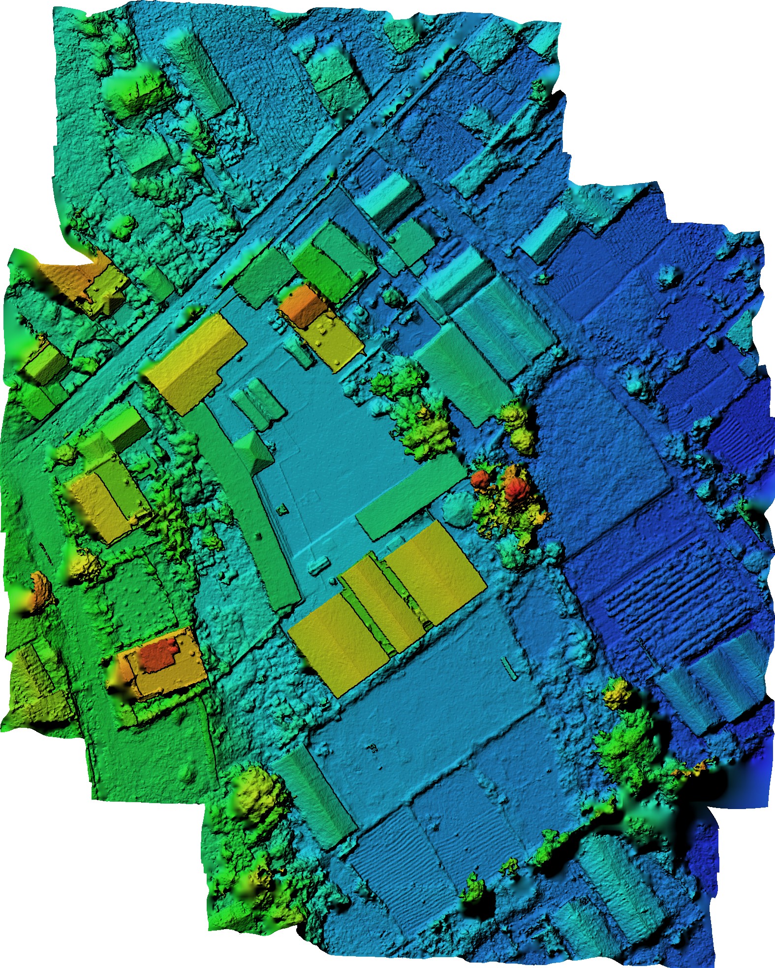
The data output is robust: orthomosaic maps, digital elevation models (DEMs), 3D site models.
Surveys that once took weeks can now be done in days — reducing cost and accelerating decision-making.
At Drone-Siddhi, we pair this capability with domain expertise across construction, energy, environment and agriculture — so your project doesn’t just collect data, it gains insight.
What We Offer
Drone Surveying & Mapping: We generate orthomosaic maps, DEMs and 3D site models — delivering the precision you need for measurement and analysis.
Construction & Infrastructure Monitoring: Track project progress, detect issues and visualise designs in real time. By integrating aerial data at every stage, you minimise surprises and optimise resource allocation.
Energy Feasibility Analysis: For solar, wind or hydropower projects, site selection is everything. We identify optimal terrain orientation and resource quality, using aerial and terrain data to guide your investment.
Environmental & Land Assessment: From vegetation health and water-flow monitoring, to erosion tracking and land-use change: our aerial data aids smarter and greener development — letting you see what counts, before it becomes a problem.
Agricultural Planning: Optimise irrigation, manage soil health and monitor crop condition from above. The result: more efficient water use, higher yields and a stronger bottom line for your agricultural operation.
Why Choose Drone-Siddhi?
Here are just a few of the reasons our clients choose us:
Speed & Efficiency: We move fast — large areas surveyed, processed and delivered in timelines that keep your project moving.
High Precision: We leverage latest sensor and photogrammetry technology to produce models accurate down to centimetres.
Safety First: We remove the need for risky terrain access, scaffolding, or disruption to ongoing operations.
Contextual Expertise: It’s not just about collecting aerial data — it’s about integrating that data into your business domain (energy, construction, agriculture, environment) to drive action.
Sustainability & Insight: Using drones means minimal disturbance to sites, less labour-intensive work, and a smaller footprint for your survey/monitoring workflow.
How It Works – From Flight to Insight
Our workflow is simple, transparent and built to deliver results:
Planning — We partner with you to define goals, site boundaries, deliverables, scheduling and safety considerations.
Data Capture — Our drones fly the mission to capture high-resolution imagery, sensor data and positional information.
Processing — Using industry-standard software, we turn raw data into deliverables: orthomosaics, DEMs, 3D models, analytics.
Delivery & Insight — You receive visualisations, measurements, reports — and we support you in interpreting them for action.
Follow-up & Monitoring — For dynamic sites (construction, agriculture, environment) we offer repeat surveys to track change over time, giving you trend data and early alerts.
Realising the Future — With Drone-Siddhi
Imagine being able to:
See your entire project site in 3D before the first brick is laid.
Monitor work-in-progress from above and catch deviations before they become costly.
Choose the perfect ridge, slope or valley for a wind-turbine or solar-farm investment.
Detect soil stress or irrigation gaps via aerial imagery across hundreds of hectares.
Visualise erosion or vegetation change over time, enabling proactive ecological response.
That’s not tomorrow’s world. That’s what we deliver today — with Drone-Siddhi.